709-218-7927 The Landfall Garden House 60 Canon Bayley Road CANADA A0C 1B0 |
|
|---|
.JPG)
By GO Transit to Hamilton for the Day - Planning
Getting There and Back
From Union Station to Hamilton GO Centre:
Depart |
Arrive |
|
|---|---|---|
5:40 |
7:25 |
1:45 |
6:13 |
7:44 |
1:31 |
6:55 |
8:26 |
1:31 |
7:13 |
8:49 |
1:36 |
7:33 |
9:19 |
1:46 |
7:43 |
9:19 |
1:36 |
From Hamilton GO Centre to Union Station:
Depart |
Arrive |
|
|---|---|---|
15:59 |
17:41 |
1:42 |
16:59 |
18:41 |
1:42 |
17:29 |
19:11 |
1:42 |
18:02 |
20:11 |
2:09 |
18:31 |
20:11 |
1:40 |
19:01 |
20:41 |
1:40 |
Reckon on 90 minutes each way except for the rogue departure from Hamilton; why spend an extra twenty minutes hanging around a GO train station? The normal delays and cancellations will add twenty minutes already!
Hamilton Transit
... is named “Hamilton Street Railway” for historic reasons. It’s all rubber-wheeled buses.
I experienced problems navigating the web site; in particular I could not find a PDF map of the entire system, and wrote an email which resulted in HSR mailing to me a copy of their paper-map; so all is well that ends well.
A Wikipedia page tells me “HSR routes from downtown to the Mountain (20, 21, 22, 23, 24, 25, 26, 27, 33, and 35) currently use MacNab Transit Terminal, while several lower city routes (4, 6, 7, 8 and 9) have an on-street terminal layover at the intersection of Main and James Streets. 34 has a layover location on King at James.”, and this may be a basis for exploration if these routes all operate radially from the downtown core.
Also: “ Hamilton GO Centre , serves as the terminus for four HSR routes (1, 2, 3, and 51).”
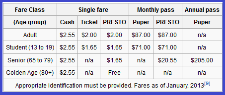
The same Wiki gives a concise summary of fares.
It is not clear to me if the “Route 99 - Waterfront Shuttle (2008).” Is still operating.
The Triplinx web site provides a means of planning a trip; although I plan to just meander haphazardly around the city.
I saved web pages with Go Transit schedules but the page construction means that we get to see only what was on the screen at the time of the save. I can’t scroll down to see useful (to me) data. Sigh!
Within the city, the Hamilton Street Railway or HSR offers good service in the lower city (especially on east-west routes), reduced service on the Mountain and skeletal service outside the old city of Hamilton (except for Dundas , which is served about as well as the Mountain).
I might take lunch in Dundas, I suppose.
Fares & Transfers
A cash fare of $2.55 for adults, seniors too; or buy 5 tickets for $10 ($2 each if you use them up!). There is a Presto Senior e-Purse fare of $1.65, but it’s not clear to me whether my senior-tagged Presto card will get me this fare without further ado.
There is something called an HSR Day Pass: “One $9 HSR day pass allows 6 people, up to 2 adults and up to 6 children (no more than six people in total, group does NOT need to be related) to use the HSR for an entire day” which seems to be the equivalent of the Peterborough Transit System $8 day pass which worked so well for me.
I assume that I’ll be able to buy a Day Pass as soon as I get off the GO Transit bus.
The printed transfer will give you two hours to transfer between buses.
“Transfers with PRESTO: Transfers are recorded automatically when you use your PRESTO card. You will have two hours to use your transfer from the time that you tap your card on the PRESTO Payment device on the bus. The next time you tap your card the system will recognize the transfer and no fare will be deducted.”. I *think* that this means that one tap of the Presto card gives me TWO hours of riding the buses, after which I pay another fare. If so, then this means that judicious use of my Presto Card means I travel for $1.65/2 or $0.83 per hour. And that would mean that if I travel less than 11 hours, I’m better off with Presto than with the $9 HSR pass.
Overview of the City
I managed to download a detailed PDF map of the HSR routes across the city.
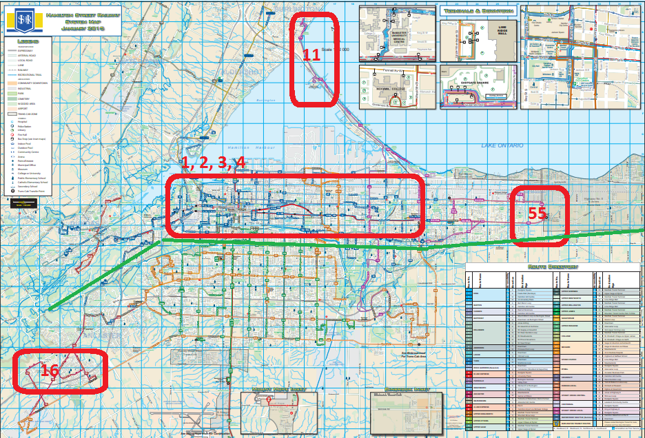
My experience is that everything becomes clearer once I am there, but from here it appears that the #11 will give me a tour of some of the waterfront; #16 will take me a little way up into the hills, although not to (#5) Dundas; #55 will give me a tour of the east end, and the inner-city routes 1, 2, 3 & 4 will introduce me to the downtown region.
I suspect that if I cover all seven of these routes I’ll have seen quite a bit of the city.
Naturally, all bets are off if one of the bus routes takes me past “The Museum of The History Of Computing” or similar!
Hamilton lies partly on the lake plain and partly atop the Niagara Escarpment. I have shown the division approximately with a solid green line.
Bus Route #1 KING
Runs E-W between Eastgate Square and McMaster University; through the GO centre;eastbound along Main, westbound along King; every 10 minutes or less.
Bus Route #2 BARTON
Runs E-W along Barton Street (James and John Streets) between the GO Centre and the Bell Manor Loop; every 10 minutes or less.
Bus Route #3 CANNON
Runs E-W along Cannon Street (between the Barton and King Street routess) between the GO Centre and Roxborough Park on Reid Avenue (Red Hill Valley); every 20 minutes or less.
To the best of my knowledge Hamilton Street Railway is the only Transit Authority in the world that produces maps designed for expatriate Aussies:-
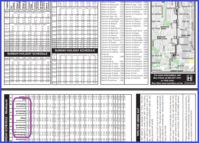
Made me feel right at home!
Bus Route #4 BAYFRONT
Runs E-W through the industrial area parallel to the lake shore. Between the McNab Terminal – which appears to be a synonym for The GO Centre –and at the east end of the route heads south (at the foot of the hills) in the Mt Albion loop; every 20 minutes.
(later)
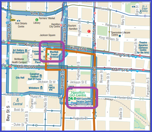
The “Go Centre” and the “MacNab terminal” are close but separate cluster points. I will arrive at the GO Centre and find the Hamilton Street Railway service centre there along with bus routes 1, 2, 3, 6 & 51.
I can walk to MacNab and routes 1A, 20, 21, 22, 23, 24, 25, 26, 27, 33 & 35, although in doing so I’ll have to avoid being run over by almost every other bus route in the city (grin!)
Bus Route #11 PARKDALE
This route runs N-S across the east end of the city; it runs between the Burlington Bus Terminal (so maybe I don’t have to go home by GO Transit after all!) and travels east along the lake shore until heading south along the east side of the Red Hill Valley to end up looping through Albion Estates(?) on the top of the Niagara Escarpment; every 30 minutes.
Bus Route #16 ANCASTER
Tricky one, this; runs westwards from the Meadowlands terminal (for which access via #5, #41 or #43) to the corner of Ancaster Business park, from which one can return via #44; every 30 minutes. A sweeter route might be #5 or #52 into Dundas.
Bus Route #55 STONEY CREEK CENTRAL
Runs E-W Between Eastgate Square () and the Stoney Creek Municipal Service Centre; outward along Queenston Road and inward along Barton Street (see #2); every 30 minutes.
I find the route description confusing:-
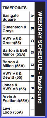
Starting at Eastgate Square (#1/1A) east along Queenston, cross grays, cross Green and according to the main map continues eastwards, but accorin to the schedule (above) goes through “Barton and Bell Manor” – but Barton is for the return trip, surely? “Queenston & Millen” would make more sense. Highway 8 & then DeWitt make sense. “Arvin & Fruitland” is the little loop to the north of Bartonthrough the Stoney Creek Business Park, and the Levi Loop seems to be a part of that.
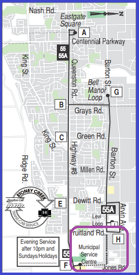
Then I spot the dotted line on the schedule map which dotted line does not show up on the main map.
This is a route to ask about BEFORE boarding a weekday bus; I think that there are two routes, one shuttles E-W along Barton and doesn’t talk to the other route which shuttles back and forth along Queenston. Although the full system map makes it look as if the #55 makes a rectangular loop around the north-east corner of hamilton City.
Bus Route #41 MOHAWK
This is a day-tripper! Runs both N-S and E-W between the industrial area of Hamilton Harbour (#1, 2, 3 or 4) and the Ancaster (#16). After Brock University it heads up the escarpment and runs west along Mohawk Road to Meadowlands; every 20 minutes between the Industrial area and Mohawk/Rice, but every 40 minutes to go beyond Mohawk/Rice to meadowlands.
Downtown Core
Presto
The Presto Card is still a bit of a mystery to me. The web page “Transfers and Connections” tells me that “You will have two hours to use your transfer from the time that you tap your card on the PRESTO Payment device on the bus. The next time you tap your card the system will recognize the transfer and no fare will be deducted.”
If I have understood this one could “game the system” by timing the final transfer in a 2-hour window to take place mere seconds (OK, minutes) after boarding a bus for a long-term trip.
The #11 Parkdale is a 40-minute trip from the Burligton Bus terminal to Valley Park, but I’d probably be boarding it partway through the trip at barton/King area.
Transferring from the #4 to #41 MOHAWK immediately before my 2-hour limit expires would mean a trip (Industrial Area to Meadowlands) of about ??? minutes on top of the 2-hour transfer window. (More skulduggery needed here! Although it’s probably not worth it, except as academic interest).
The bottom line, I think, is that if I leapt from one bus to another without a break, four tickets would mean effetcively eight hours of rides, more than anough for any young man.
There again the #5 from ? It comes and goes from downtown but I don’t see it listed on any downtown terminal!
Thursday, July 02, 2015: I called the Presto help line and was assured that my interpretation was correct: I get two hours of boarding after I tap my card; and if I wanted to game the system I should time my boarding of a long bus route (e.g. #11 Parkdale) right at the 1h 59m mark.
Loading
709 218 7927 CPRGreaves@gmail.com
Bonavista, Wednesday, June 03, 2020 7:55 AM
Copyright © 1996-2020 Chris Greaves. All Rights Reserved.