A goal of my recent trip to Pittsburgh, was to travel and study the Pittsburgh-T (T for Trolley) which I rode some quarter of a century ago.
The little system is built on an unused rail line. Doubtless time and effort was spent bringing the track up to passenger standards, signalling and so on, but no need to purchase right-of-way.
And the neighbours ought to prefer a quiet electric car to a lengthy diesel freight train.
We drove across town to the West Library station of the BLU (sic) line of the T.
Google maps said that the best route to get to the end of the line was to take the 376 to downtown Pittsburgh, then drive out again.
I stubbornly refused to drive downtown so I could drive out of town to catch the trolley to downtown, so we went across town, putting our trust in the GPS.
Navigation is made difficult by the fact that most of the time you are driving in a deep valley; cross-city landmarks can’t be seen. Downtown Pittsburgh can’t be seen as you approach from the south until you pop out of a tunnel on the bank of the Monongahela River.
OK. So we drove carefully and arrived at the station just in time to see the train depart without us. Sigh!
That’s the rear-end of the train, having squeezed past the track crew, and now waiting at the next station down the line – Sandy Creek.
Note the overhead wire – catenary system. No live rail at track level.
Safer!
You can see that some parts of the line are most scenic; they reminded me of the Rockwood railway museum, west of Toronto.
While we waited I took photos.
The far side (track to downtown) boasts a bus-shelter. A pedestrian concrete ramp leads off to the right, up from track level to car floor level. In the end we boarded our downtown train from track level.
On our side, I am standing at the foot of the ramp and Ms B is standing on the platform. Our side doesn’t get a shelter because generally speaking this far out of town folks get off the train and get in their automobile and drive home.
Here is a close up. Consider the size of the platform – about eight feet square.
Across the track a fruit tree shows off. We had no blossom in Toronto when we left (and none when we returned five days later)
Here comes the train from downtown; a bus edges to the track, too close IMHO.
The driver wouldn’t let us on to ride out to the end of the line; he told us to wait ten minutes and he’d be back. Library is the terminus, and it is the next stop.
The trolley driver is a bus-driver; personalised service and attention. Nor cordoned off in a complex subway car, but operating as a streetcar driver would in Toronto.
Note the two sets of doors. The large double-set is at platform level. Forwards of it, a narrow door is at track level.
Where a station boasts a platform, the platform-level door will be opened; where only trackside access is available, the track-level door will open.
Bye-bye little train; we’ll see you in ten minutes,
Here is the ramp for the opposite platform. The ramp links the shelter at track level with the platform.
I passed the time taking photos. We parked the car in the lot marked “For LRT patrons only”. After all, we are patrons. Only later did we realize that the lot id for patrons who have bought a monthly parking sticker.
Will we get ticketed? Towed? Read on, dear reader, read on.
The Pennsylvanian Alps can be seen in the distance.
Here is a better shot of the 64 square-feet platform on the opposite side.
It is a bit more than a cubic yard of concrete poured onto the ground between four pieces of four-by-four, but not much. A simple structure filled with concrete; rough timbers for railings. OK, you’re vulnerable to splinters, but don’t we already know to watch out for splinters?
This is a low-cost platform – low in cost of materials, low in cost of labour, and I bet a truly low cost in time of development. I can see the local hadlines: “Work began this morning, scheduled for completion in time for the 16:05 out of town tomorrow”
The driver picked us up with the track-level door on his return. He refused to take our money. Very strange.
Regulars tap a transit card on the orange block, or feed bills into the slot. We had bills. Money wasn’t the issue.
I got brave enough to ask the driver for a transfer anyway, as a souvenir.
Bigger stations surface the closer we get to downtown. This is Lytle, pronounced “Light-ell”.
At this station all the doors on all the (four) cars will open; passengers get on and off through any door. Stations such as this have a five-foot square booth that houses a ticket collector. You pay your fare/tap your card as you get OFF the train.
We found that in the downtown core, no one is expected to pay or tap as they board the train. Downtown platforms see a lot of people boarding the train at once. People board without slowing down to tap cards/feed bills into a machine, so boarding at the busiest stations is super-fast What a concept!
I noted that we passed through several stations without stopping; no passenger had pressed the request-stop button, and no one was waiting to board at the station, so the trolley trundles through without stopping.
What a concept!
Of course, this might mean that trains run a little bit ahead of schedule, but we can accommodate this. I suspect that they have timing stops at the places like Washington Junction.
We went through several junctions and entered a tunnel.
I was most impressed, since (near BOGGS station) regular road buses share the track surface with the LRT. Makes sense. I tried to get a photo of an oncoming bus, but failed.
When we are finished our refreshments we will enter the Gateway station, shown here with its glass shelter, and take the “T” back to the car.
We are back on the train. Check out this platform for economy. It is a concrete slab with railing, set at track-level. For this station, the track-level doors open while the platform-level doors remain closed.
I have visions of the very clever people of Pittsburgh saying “Let’s have a station HERE”, and someone running out into the street, flagging down a passing concrete truck and asking if they can cadge a cubic yard of concrete while the other two guys drag four pieces of four-by-four to make a square; level out the concrete and by tomorrow morning they have a new station on their LRT.
In Toronto we have a multi-year study, build stations thirty feet above road level, and get a train that can’t function when it snows. (Who knew that it would snow in Toronto AFTER the Scarborough LRT was built!)
Here is our train, its platform-level doors closing. The track-level door, peeking in on the right, remains closed because here at West Library we have a platform.
Bye-bye train. Our train out of town was two 2-car units.
Here’s why you don’t need big platforms at the end of the line; the parked cars give you a clue: Folks coming from downtown get off the train and they don’t hang around on a platform – they go straight to their cars and drive home! What a concept!
Same deal for folks going INTO town; you sit in your (parked) car until the train goes by on its outward journey, you count for ten minutes, then leave your car and walk the twenty yards to the station just as the train arrives on its downtown journey. What a concept!
Farewell!
Pittsburgh transit system uses a tap-card called ConnectCard. I didn’t buy the card, which is geared to monthly use, but I did collect this pamphlet.
I forget how many pages, perhaps ten sheets stapled down the middle, so say 40 column-pages.
Arranged by location, you get hefty discounts (around 20%) for most of the entries.
Toronto should consider this; buy a Metro Pass and get discounts from local businesses.
Here is some detail of one page.
I saw a message similar to this on the Jacksonville transit system. Toronto should use the slogan. If you see something, say something; break down the barriers, make a consensus. Perhaps someone should sound the alarm? We shouldn’t just sit there hoping that everything is going to be all right.
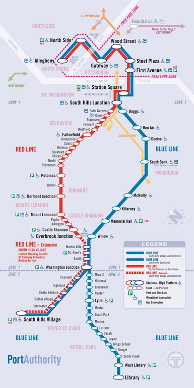
Note the free-zone area in downtown Pittsburgh; ride the LRT/subway or the buses to get from one point to another. Leave the car at home.
FWIW neither driver inward trip and outward trip) would let us pay a fare. We were seniors or disabled (?) or something. We qualified for free rides even though we didn’t know why we qualified?
I suppose that in the grand scheme of things, letting the out-of-town visitor ride for free doesn’t put a big dent in revenue.
It surely added to our positive impression of the transit system, and hence, of the city of Pittsburgh.
Here is a portion of a pamphlet of the LRT system. The system serves southern districts only, with the red line swelling westwards for a while.
Except for Station Square, the downtown LRT is free. The stations Allegheny and North Side serve the new sports stadiums, I think.
Trains run every ten to fifteen minutes during off-peak hours.
The trip from Library/West Library to downtown is just under 45 minutes.
And the scenery is beautiful; tree-lined avenues with just the rails; an occasional glimpse of a village’s commercial centre.
Here is a bus route that doesn’t extend as far as the Ohio river bends.
Pittsburgh transit doesn’t push the bus into the heart of the downtown district; passengers switch to the LRT, which costs time-of-transfer, but is probably faster than having the bus wend its way through the downtown core.
Let’s see how that would work in Toronto.
Here is the transfer point. The bus route arrives at the left-hand side of the map; passengers transfer to an LRT train (Red or BLU line!) within the free Fare Zone.
Smart!

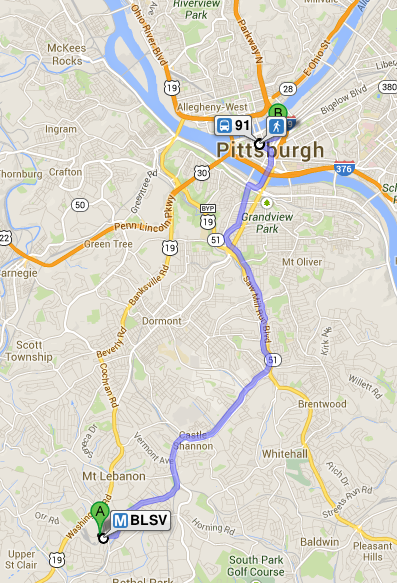
Here is a Google Maps view of the Red line’s route through south suburban Pittsburgh.

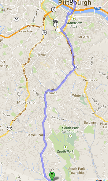
Here is a Google Maps view of the BLU line’s route through south suburban Pittsburgh.