709-218-7927 The Landfall Garden House 60 Canon Bayley Road Bonavista, Newfoundland CANADA A0C 1B0 |
|---|
Fort Walton Beach
Tuesday, February 11, 2014
Location |
Odometer |
Time |
|---|---|---|
Jacksonville |
58,173 |
09:30 |
Tallahassee |
58,461 |
12:30 |
13:45 |
||
58,611 |
15:00 |
|
Defuniak Springs |
58,649 |
15:35 |
Fort Walton Beach |
17:00 |
Following our stay in Jacksonville , we are heading due west across Florida, almost as far as Pensacola. I know the way – Highway 10 out of Jacksonville almost to San Diego.
But just for laughs I decide to ask the Garmin GPS to take us to Tallahassee – our half-way point on today’s drive.
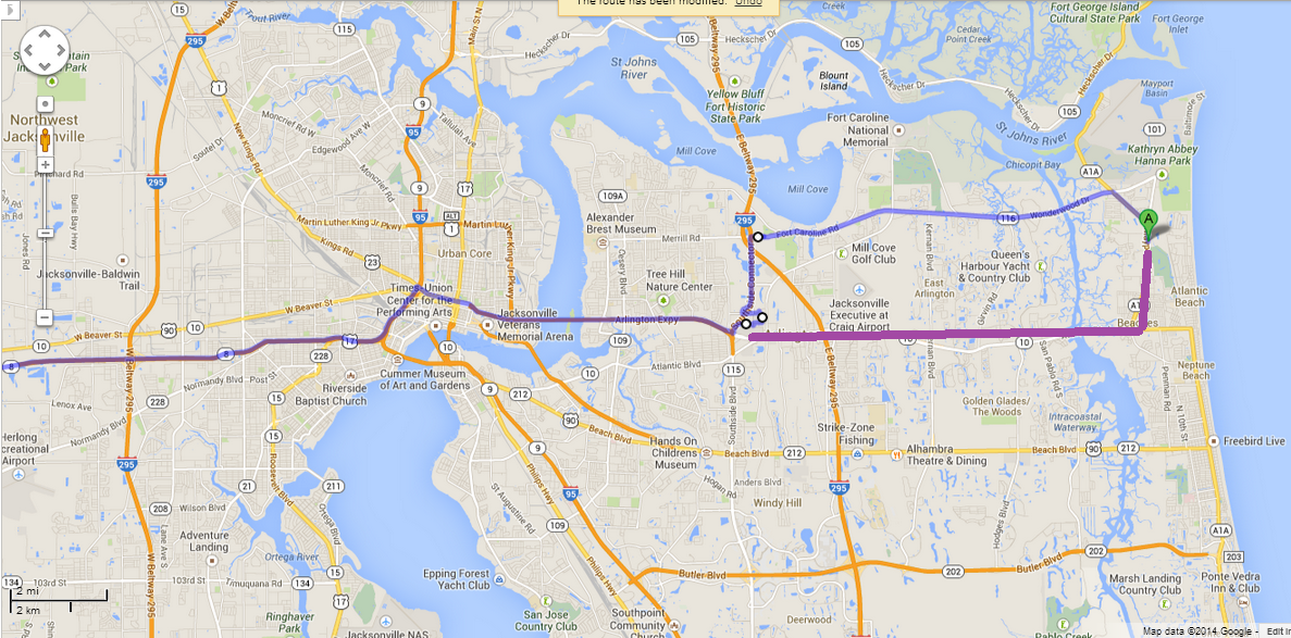
Me, I would have gone south then west along Atlantic to the Arlington Expressway, but Garmin has me drive north, then west, then south to the Arlington Expressway. Go figure.
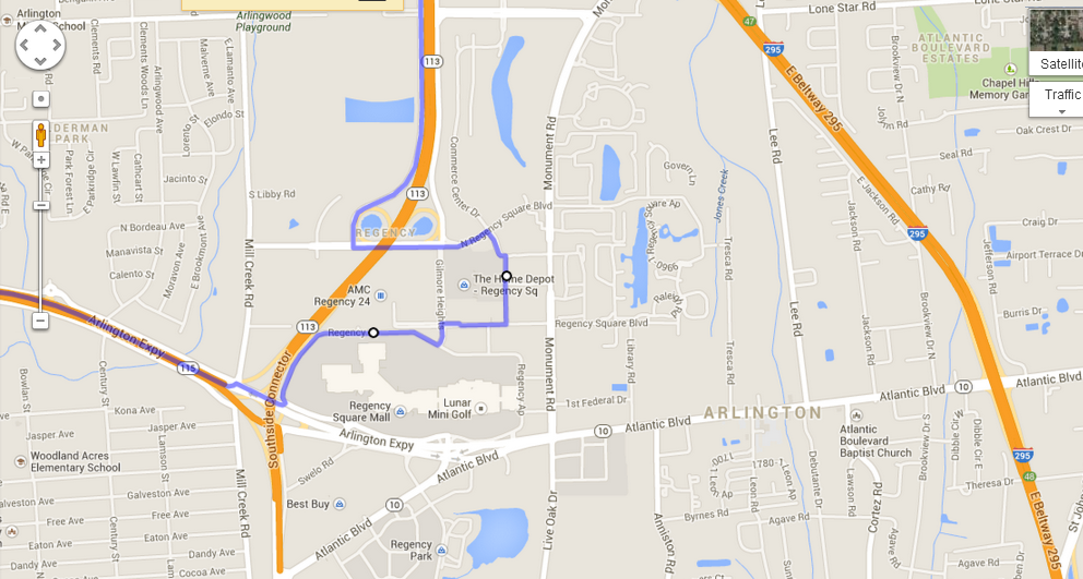
It gets worse. The Garmin Voice passes us UNDER the 295 ring road and onto some southbound collectors, then steers us right through the un-named “alleys” of a shopping mall.
Look at the map above. We by-passed both highways 295 and 113 then weaved through the mall!
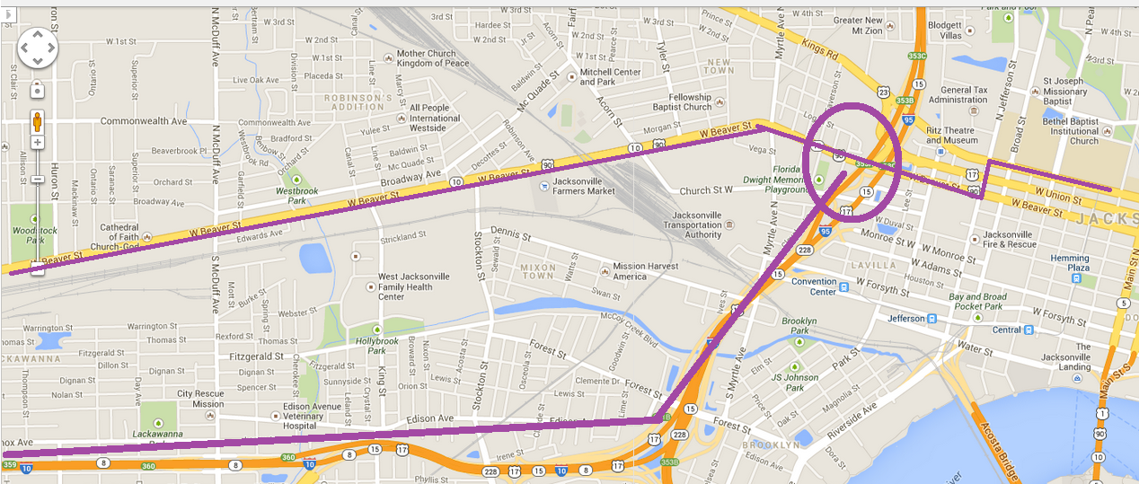
We (were) rocketed through the core on State Street, sent south down Jefferson, and then launched onto Beaver street.
Why, I asked myself out loud, wouldn’t we be put onto the major Highway 10. Seconds later Garmin Lady said “Proceed on Beaver Street West for sixty-three kilometres”, and I tossed in the towel, did a U-turn, and headed back to I-95 and I-10.
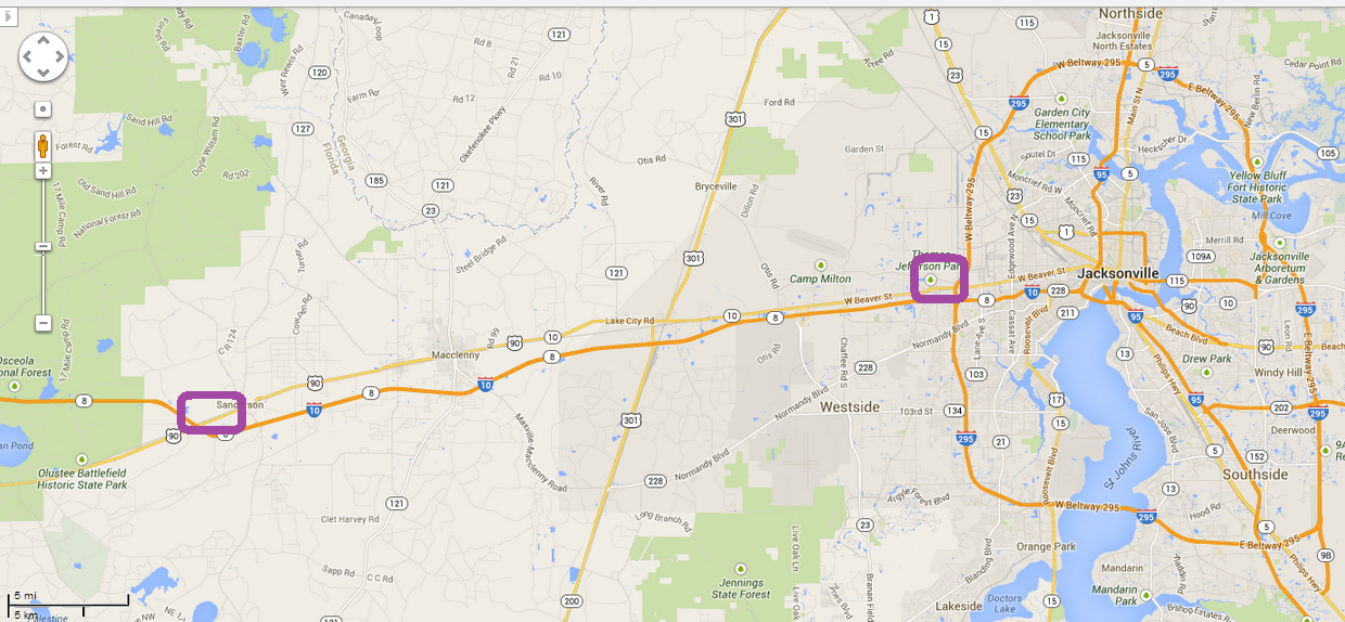
Here is what 63 Km looks like when you go on Beaver Street!.
Bottom line: This GPS will ultimately get you to your destination, but it will not always be the best route for someone who is lost
But see “Yacht Club Road” below!
Here is our cheerful USA Today map – Cold and wet after we leave Tallahassee. For the rest of the day.
The morning was bright enough. We set off at 9:30.
Two hours later, the cloud bank looms ahead of us.
And by afternoon, it is faintly ominous; this is cold rain-bearing cloud.
We broke away from I-10 and came south down highway 331 from Defuniak Springs.
By this time we have driven for an hour through spitting rain.
Here we are over Choctawatchee Bay. The rain gets heavier.
The sky starts to blend into the water-laden air.
We turn west on Highway 98 and begin the fifty mile drive in heavy rain to Fort Walton Beach.
And here we are at Journey’s End, sort of. The rain has not stopped. Puddles are common.
A black cloud follows me wherever I go.
I park the car and trolley our bags upstairs.
I stare at the rain drops …
The view from the balcony is gorgeous – rain as far as the eye can’t see.
That’s the Okaloosa Island fishing pier in the background.
The rain stops long enough for us to see how great this would all be if the air were warm, the sun shining.
Then the rain kicks up again. No one walks along the beach.
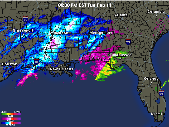
Meanwhile, back at the ranch …
… The evening weather chart looks like freezing stuff for us overnight.
Wednesday, February 12, 2014
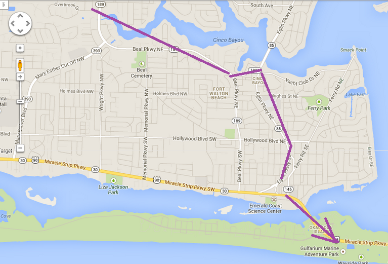
More about Garmin. It was absolutely pissing down last night, but some schmuck has to find his way to Wal-Mart after nightfall, buy a $7.48 toaster, and head back to the hotel. Before leaving the hotel, I key in my new “Home” address.
I drive up Beal Parkway NE directly from Highway 98, find Wal-Mart, buy the toaster, and ask the Garmin Lady to send me home. Garmin tells me to get OFF Beal Parkway – the simplest and most direct route home – and tells me to cut across Yacht Club Drive to Eglin, then a ballooning loop down Elgin to highway 98.
Not the simplest way home for a newcomer, the person most likely to be using a GPS, and wanting a straightforward way home.
To make it worse, as I pulled into the hotel parking lot, on the right-hand side of the road, Garmin was prompting me to keep on driving and to make a U-turn!
I will try that trip again before we leave, when I’m not tired, when it’s daylight, when it’s not pouring rain.
For trip planning we couldn’t find the scale on the map, but Mister De Kurloi, my Governor Stirling Senior High School geography teacher, told us that one degree of latitude was about seventy miles, and waddya know, there on the left-hand side are the degrees of latitude for 29, 30 and 31. My hand span is eight inches, and so I find that eight inches is about 140 miles, or about seventeen miles to the inch.
This works. My navigator says “about an inch to go” and I think “about twenty miles”.
This morning I found the scale on the map.
Seventeen miles to the inch.
Thank you Mister De Kurloi!
A panoramic view of a deserted beach. The waves have picked up.
Eleven o’clock. A coated man walks the beach, head down, hands in pockets.
Seagulls masquerade as tourists.
We lunched at Whataburger . The sign “Family owned and operated” caught our eye. Turns out it is a chain of over 700 hamburger stands.
I liked this hoarding. The two cows are three-dimensional models.
The hoarding can be seen near the Chick-Fil-A , 743 Beal Pkwy NW, Fort Walton Beach, Okaloosa, FL 32547.
Every corner of every parking lot tells a story.
Thursday, February 13, 2014
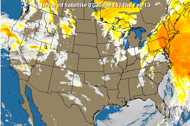
Take a look at the Florida peninsula and the cloud cover to the west and east.
The clouding stops right on the coast, but the clear patches – blue streaks – continue either side.
It appears that the land mass interrupts the temperature at which clouds form.
Now I think that the land mass is colder than the moist air above the Gulf Stream, so that the moist air cools as it crosses the west coast, drops rain, then regains moisture as soon as it reaches the east coast with the resumption of passage over the warm Gulf Stream.
Note also the demarcation at the Texas coastline.
“Get it out!” were the screams as I read my Harpers in bed this morning. “Get what out?”. “The bird, The BIRD!!”. Our room is not that big and I thought I would have heard a bird fly in.
Closer inspection reveals a pigeon making itself at home, poking around the little plastic garbage pail.
The little bugger was quite domesticated; it had no fear of me as I, like it, padded barefoot across the carpet.
With Ms B barricaded in the bathroom I took to tossing chunks of bread against the bathroom door.
("I can hear it pecking at the door!" 


 )
)
He/she/it was quite unconcerned in my presence; obviously used to being fed indoors.
I have named it "Sunday Roast"; we have booked the room for 3.14159 more days ...
Here is a photo of my left thumb not obliterating the door to our unit – 4 in from the right, 2 up, with a plastic chair wedging open the door.
A better view. I have not thought it warm enough to sit on the balcony, but with the door wedged open we can hear the waves breaking on the shore between the roar of helicopters scooting up the coast line at about two hundred feet on their way back to Hurlburt Air Force Base.
The view to the west.
The view to the east.
We are an insignificant couple in an insignificant unit in an insignificant hotel in a chain of common hotels along a non-descript stretch of coastline.
Here Ms B waits for me to take her photo. Note the jacket that makes her look like she just got off the yacht …
We inspected a few condo units. Here Ms B waits for me to take her photo.
Here Ms B is asking me if I’ve taken her photo.
Now this is the sort of building that idiots like me use as a reference point for navigation, until smart guys like me realize that 50% of the hotels are tall, beige coloured, with orange roofs.
We tooled out on 98 West until we reached 399, then leapt across the lagoon to take the beach road from Navarre Beach park to Pensacola Beach.
A set of about one dozen high-rise buildings, tall, beige coloured, with orange roofs, have been plunked down here.
Then out along the snow-covered road (hah hah!).
Here are those units in better light.
And so to lunch. After seeing the hoarding yesterday, we had to try it. Chicken-in-a-bun is all it is. We were not impressed.
The sign indicates how cold it has been; soup-kitchens in Florida?
399 crosses a lagoon to reach Gulf Breeze, and then we motor over a five-kilometre bridge to reach the mainland again.
A cup of tea and then it’s time for my evening walk. (I always take an evening walk on the 13th of the month)
Here we are, one day away from a full moon.
There’s Ms B waving goodbye to her brave hero.
I cheated and did not walk barefoot in the water. It is too cold.
Waving is finished. It’s time to start walking.
“ Just me, and my shadow , walking down the …”
Another zoom shot of the hotel.
Why do vacationers feel compelled to take sunset-over-the-ocean shots? See next picture for the answer.
Because away in the distance we can see those dozen high-rise buildings where 399 hits Navarra State park!
Friday, February 14, 2014
OK (grudgingly), the weather has improved, but it’s still not hot.
I went for a walk this morning, eastwards along the beach.
Lots of folks were out before me.
There are baffles along the edge of the dunes; I imagine they trap wind-blown sand.
It’s been years since I’ve watched the waves lap the shore and sink wetly into the sand.
We are not allowed to leave the beach, except by special wooden walkways which bridge the dunes.
Most folks are rugged-up against the cold. As in rugs, not as in “are rugged”.
This hotel stretches north to Miracle Strip Parkway, then a pedestrian bridge spans the road to reach the hotel on the northern side of the roadway.
I was struck by how these feet are angled out. There is a difference of almost ninety degrees.
There’s Ms B, reading her book!
We headed off to a donut café in Destin, and passed this turreted hotel. I was shooting into the sunshine, so it is a silhouette shot.
Off to the De'France Indoor Flea Market; at the front door you are in Florida, but partway to the back you cross the Alabama state line, it seems.
This shot is from the rear, barn “4” in the foreground, if you like.
Saturday, February 15, 2014
Our friend returned this morning and brought a friend. The two of them pecked at a piece of bread while we stood next to them on the balcony.
Here is someone sunbathing. Fully clothed with a cap over his face.
I can’t see the point of sunbathing on the beach while fully-clothed.
Unless it is done for hypothermic avoidance.
By mid-afternoon the beach was populated, albeit lightly.
There is going to be a beach wedding this afternoon; a crude veiled thingo has been erected on the beach.
Out of the wind we felt warm, but on the beach a chill northerly breeze sent us scurrying back to the hotel.
Folks who have dressed warm can brave the beach.
I wandered around the rear of a mall in the afternoon. There is a pool or pond, fed by storm water from the plaza parking lot.
As I understand it, rather than invest Millions of dollars in a storm water drainage system – a tough project in a land as flat as Florida – storm water is treated locally, and settles in pools to evaporate or to sink, slowly into the ground.
About the centre of the photo is the channel that streams the water into the pond.
Here is the channel with a view of the pond.
We drove Brooks Street, under the bridge, and caught sight of two pirate sloops. They are used in the Billy Bowlegs Pirate Festival .
While from the same spot, looking eastwards, I see the bridge to Destin, with that turreted hotel visible just to the left of centre.
Then tonight I broke down and experimented with various camera settings.
Finally some shots of the beach, no flash.
And a last shot of the sunset; no flash.
Sunday, February 16, 2014
A lazy day; mid-afternoon we looked at about a dozen condo rentals (separate page).
Here are our latest friends lined up and waiting for breakfast.
I crushed a mini-wheat for them; unlike the pigeons, these sparrows beaks can’t break toasted cereal.
The sparrows took turns eating; perhaps this flock-separation is an evolutionary means to avoid the entire flock being captured.
Here three sparrows eat while a fourth takes a break from eating and – stands guard?
I lured one hungry chap into our room; the next guests who stay in the room will curse me.
Mid-afternoon I spot a guy sunbathing on the beach.
It turns out to be a guy and a gal, fully-clothed, the wind is biting.
Here is Ms B, trying, like me, to look as if we are enjoying ourselves on the beach.
I spotted this roll of snow-fencing alongside one of the beach condos.
In Ontario our snow-fencing is coloured orange, not bleached by the sun.
Then on the path back over the dunes I saw a small green leaf poking through the sand.
How can it survive in the middle of a path?
In close up; the leaf is about one centimeter in diameter.
Here is part of the answer; a chain of dry leaflets indicates the existence of a creeper-root that lies just below the surface of the sand.
Here is the tip, so to speak, of the creeper. It has made its way half-way across the path.
And there lies the secret of dune restoration. Basically, keep human activities out of the dunes, and the vegetation will look after itself, the way it has done for hundreds of millions of years.
These trees have fascinated me. They are common around Fort Walton beach. Some of them lined along Highway 98 are, I think, forty feet high.
From a distance the leaves look like Jade plant leaves, but up close I see the tips have a point.
Monday, February 17, 2014
Packing, mainly. We were under cloud early on, but the sun came out around noon.
I bought two pairs of pants and we had an excellent low-cost supper at the Shrimp Basket . A great way to celebrate the end of our last day here.
Tuesday, February 18, 2014
Just in case you think I might have been violating rules, not a single seagull came to our suite. And anyway, the pigeons and sparrows fed themselves; we just put the food out for them.
Sigh.
This morning dawned fair, but we have to go.
The planned route is up local highway 85 to local 331 thence to Montgomery, then on to the outskirts of Birmingham.
Up near the Eglin AFB is a park housing a couple of dozen war planes.
Quite an impressive sight as we flash by.
The clouds are starting to pretend they might be threatening. We know we are driving into what will be the tail-end of three days snow in Toronto.
Double-sigh.
What does 345 feet elevation look like to a Torontonian?
It is the vertical distance traveleld on the Don Valley Parkway from the Lakeshore to Highway 401.
From Wikipedia “Britton Hill is the highest natural point in the state of Florida , USA , with a summit elevation of 345 feet (105 meters) above mean sea level . Many Florida skyscrapers are taller; as of 2010, the roof of the Four Seasons Hotel Miami is the highest non-natural point in Florida. Topping out at 789 feet (240 m), the tower is more than twice as high as Britton Hill. Britton Hill is the lowest state highpoint in the United States, 103 feet (31 m) lower than the next lowest highpoint, Ebright Azimuth in Delaware . It is even lower than the highest point in Washington D.C., Fort Reno Park in Tenleytown , at 429 feet (125 m). The lowest points of sixteen U.S. states are higher than Britton Hill|
We enter pine forests, sandy soil I guess, with nice green verges off the highway.
Through the (to us) quaintly named town of OPP.
It is a tad unnerving to see the Ontario Provincial Police blazing away on every sign and hoarding!
We passed many small herds of dairy cows, and quite a few goat farms.
This strange sight caught my eye a quarter of a mile away, but by the time I got the camera ready, the speed limit sign blocked part of the sight; or maybe enhanced the puzzle.
The trees either side of the power line have been trimmed recently in dead-straight lines.
From a distance the illusion was of the sky cutting a rectangular hole through an avenue of trees.
The clear edge can be seen on the left of the hole parallel to the left-hand side of the speed limit sign.
Gas prices sank to the lowest we’ve seen so far $3.10 per gallon.
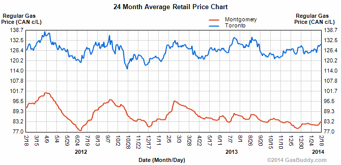
Here is a chart comparison for Toronto $1.30/litre today versus Montgomery Alabama at $0.84 per litre today.
We took the buffet lunch at the quaintly-named “It Don’t Matter” diner off Highway 331 in Alabama.
The menu reads, under the heading “Steaks”, that this section of the menu is served Friday and Saturday nights only.
The subsection “Baked Potato” reads “Friday and Saturday night only”, while the sub-section “Extra Yeast Roll” reads “Friday and Saturday night only”.
A footnote to the section reads “Friday and Saturday night only”, just in case you had any doubts.
We were there on a Tuesday, anyway, so it didn’t matter.
Here’s the front entrance to the diner.
The back of Kayla’s shirt bears a cartoon. The old geezer says “Honey, where do you want to eat”, and the old gal replies “It don’t matter”
The smiling Kayla.
The Microtel suite was up to its usual standards; roomy, neat, clean. We have a sofa on which we can sit and read.
Not quite a kitchen, but the little sink beats the heck out of rinsing tea cups and filling electric jugs from the bathroom hand basin.
The bed is a King size. I am beginning to have doubts about this. Either you sleep snuggled around each other, or you don’t.
If you sleep snuggled close, a double bed, smaller than a queen, would suffice, giving you more floor space.
If you sleep separate, wouldn’t twin beds make more sense? With individual reading lights.
My first complaint was that the room had been repainted with "air-freshener", a euphemism for a strong-smelling fluid that is stronger than the resident smell and whose odors are strong enough to overpower any other odor. And me.
My second complaint was that the window would open only three inches – blocked by a bar at the top. A three inch gap is not enough to get air circulating.
I had, however, told the receptionist that the room was three times as good as the Ramada, and only half the price. She gave me a coupon for 10% off.
Supper was at Zaxby’s – a chicken-counter place.
Here is my sachet of Mediterranean Dressing.
Here is the reverses side of my sachet of Mediterranean Dressing.
Note that the sachet represents 140 calories, or roughly half of a dieter’s meal of 300 calories.
I skipped the Mediterranean Dressing.
Wednesday, February 19, 2014
Having spent the night in Birmingham Alabama we set off for Cincinnati, or as best we could make it.
The day dawned dreary; we are heading back to cold, snow, sleet and all sorts of crud weather and we know we will regret moaning about the weather in Florida.
The roadside verges are yellow dead grass. Where is the lush green of The South?
This was shot near who-knows-where?
We took lunch at Stan’s Country Store.
I went Southern and had turnip greens, fried okra, pinto beans and stewed apple.
Ms B had bacon and eggs with grits; I think she didn’t like the grits.
We elected to drive through the heart of Montgomery. We didn’t stop because we hadn’t done our research.
Yay Rosa Parks!
I can’t remember why I took this photo; maybe it will come to me …
I have no idea what this building is, but it impressed the heck out of us.
And so on towards Birmingham. The sky begins to thicken.
We drove through road works – the highway is being widened, and the cuttings show rock strata with concentrations of iron, in some form.
Thursday, February 20, 2014
The day dawned cloudy – again. We set off.
Out of Rossport we descended a steep grade which turned out to be the banks of the Ohio river; here we move in on Cincinnati in the morning rush hour.
The downtown core looks delightful in the early morning light.
We pulled into a Tim Horton’s for a washroom-and-coffee break.
I’d not seen a sign for a parking space for drive-through customers before.
Snow-covered fields line the roadsides; an ominous sign.
The piles of snow thicken. We are dismayed, but not surprised.
We crossed the border at Detroit in record time; less than three minutes from the time we arrived at the line-up (one car ahead of us!) to the time we were home free.
The nominally four-hour trip from Windsor to Toronto stretched to five hours as we crawled at walking pace for a good distance owing to folks rubber-necking at a jackknifed tractor-trailer in the westbound lanes.
Traffic was slowed down right through Kitchener until the 410 cut off in Mississauga.
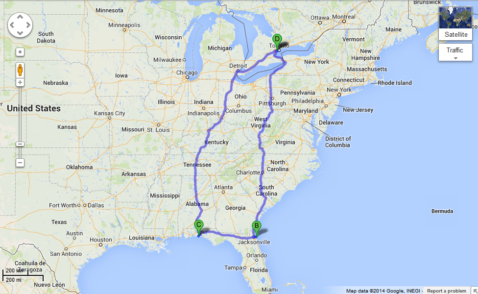
Here is the route we followed; According to Google Maps we did 4,311 Km, but we did an extra km in side-trips.
709-218-7927 CPRGreaves@gmail.com Bonavista, Tuesday, July 30, 2024 10:46 AM Copyright © 1990-2024 Chris Greaves. All Rights Reserved. |
|---|