709-218-7927 The Landfall Garden House 60 Canon Bayley Road Bonavista, Newfoundland CANADA A0C 1B0 |
|---|
Maps

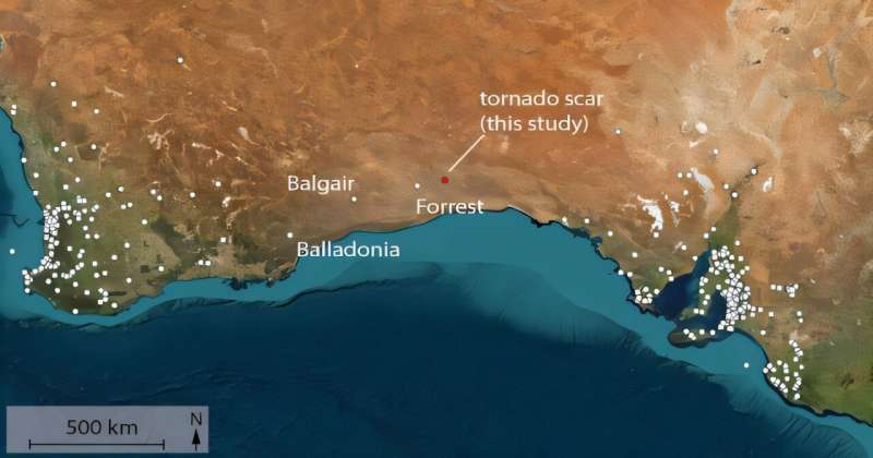
Here is a map linked from this news story .
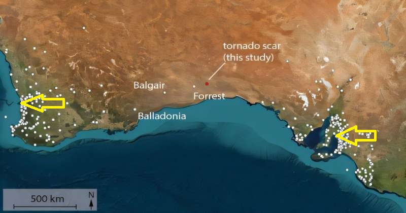
At first glance you might think that the map shows centres of population, or areas of population, or relative density of population.

To help those of you with little knowledge of Australia see this, I have placed bright yellow arrows that show where Perth and Adelaide cities lie.
The trouble is that the map is not meant to indicate population.
The funny thing is that the map DOES represent areas of population.
In the published (PDF) article the map is titled in [part “Tornado events location for Western Australia and South Australia”.
Tornadoes are whirling columns of air, regularly reported, photographed and filmed in places like Kansas and Oklahoma. Rarely reported on the Nullarbor Plain; mainly because there are very few observers on the Nullarbor Plain.
Someone driving on the highway between Perth and Adelaide has, by definition, at most a fifty percent chance of seeing a tornado, basically in the forward direction of travel of their vehicle.
“Most tornadoes last ~10 min, although some have been known to persist for an hour or more. The diameter of tornadoes varies from 10 m to up to 2000 m, and are usually ~200 m” so the target in general lasts ten minutes and is around 200 yards wide. This highway boasts a dead-straight stretch of ninety miles at one point; your mind wanders.
Note too that this tornado was NOT spotted by a human; it was identified by someone scanning images from Google Earth (for our purposes, similar to Google Maps), and as such is heavily dependent on the day that a satellite took an image of this remote part of Australia.
So what are the white dots in the map that can lead us to believe that we are looking at a population map?
Well, they represent people. Specifically anywhere from ten to a hundred thousand people.
A tornado blasts through the gas station (that’s all there is) at Balladonia, ten people would see it; A tornado blasts through Floreat Park, a tony suburb of Perth, we are looking at 100,000 residents seeing it.
The map reports observed tornadoes; observed by people.
So by definition it must be reporting places where people saw a tornado. Which means it must be reporting where people were at that time.
709-218-7927 CPRGreaves@gmail.com Bonavista, Monday, November 25, 2024 3:44 PM Copyright © 1990-2024 Chris Greaves. All Rights Reserved. |
|---|